
Running and trail running in Pune
7 loops inside Pune city, every one 5 km or more. Road loops in Koregaon Park and Kalyani Nagar, Viman Nagar, Magarpatta, Kharadi and Savitribai Phule Pune University. Trail loops on Vetal Tekdi and ARAI, and on Pashan and Baner hill. Each follows real mapped streets and paths, with its distance, a map and a GPX file.
Plotted by PuneRunners on OpenStreetMap data, 7 Oct 2026. Not run-tested yet.
City loops
-
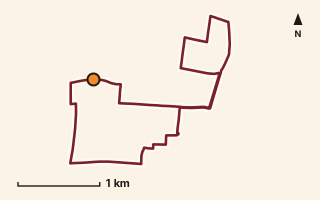
Route line on OpenStreetMap streets. Orange dot: start and finish. Road Running Koregaon Park and Kalyani Nagar
Koregaon Park and Kalyani Nagar loop
Burning Ghat Road and North Main Road in Koregaon Park, over Aga Khan Bridge to the Kalyani Nagar avenues and back across it, then Lane 7 and South Main Road.
One loop 8.62 kmUnderfoot 100% streets Elevation not recordedPlotted by PuneRunners on OpenStreetMap data Mapped only, not field-tested
Safety and access: Public streets with traffic on North Main Road, South Main Road and the avenues. Footpaths, lighting and crossings not checked.
Streets: Burning Ghat Road, D Lane, North Main Road, East Avenue, Aga Khan Bridge, South Avenue.
Route record
- Category
- RUNNING & TRAIL RUNNING
- Type
- Road Running
- Area
- Koregaon Park and Kalyani Nagar
- City status
- PUNE CITY
- Distance
- 8.62 km
- Elevation gain
- Not recorded
- Difficulty
- Not recorded
- Technicality
- Not recorded
- Endurance
- Not recorded
- Navigation
- Not recorded
- Exposure
- Not recorded
- Remoteness
- Not recorded
- Terrain
- 100% streets (from OSM highway tags)
- Surface
- asphalt 63%, not tagged 27%, concrete 9% (OSM surface tags)
- Monsoon risk
- Not recorded
- Heat risk
- Not recorded
- Wildlife
- Not recorded
- Water
- Not recorded
- Mobile network
- Not recorded
- Emergency access
- Not recorded
- Beginner suitability
- Not recorded
- Start
- Burning Ghat Road (18.54225, 73.8902)
- Finish
- Burning Ghat Road (18.54225, 73.8902), a loop
- Nearest landmark
- Aga Khan Bridge
- Creator
- PuneRunners, plotted on OpenStreetMap data
- Source
- OpenStreetMap streets and paths
- GPX
- Yes
- GPX link
- GPX file
- Licence
- ODbL 1.0 (derived from OpenStreetMap)
- Reuse
- Ours to publish; credit OpenStreetMap contributors, share-alike
- Route date
- 7 Oct 2026
- Last verified
- Not recorded
- Data confidence
- Plotted on mapped streets and paths; not field-tested
- Safety notes
- Public streets with traffic on North Main Road, South Main Road and the avenues. Footpaths, lighting and crossings not checked.
-
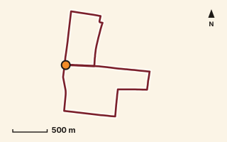
Route line on OpenStreetMap streets. Orange dot: start and finish. Road Running Viman Nagar
Viman Nagar loop
Airport New Road, Symbiosis Law School Road, Viman Nagar Road and Sakore Nagar Road, round the Viman Nagar blocks.
One loop 6.17 kmUnderfoot 100% streets Elevation not recordedPlotted by PuneRunners on OpenStreetMap data Mapped only, not field-tested
Safety and access: Public streets near the airport roads. Traffic, footpaths and lighting not checked.
Streets: Pratapkumar Path, West Avenue, Symbiosis Law School Road, Airport New Road, Anand Vidya Niketan High School Road, Viman Nagar Road.
Route record
- Category
- RUNNING & TRAIL RUNNING
- Type
- Road Running
- Area
- Viman Nagar
- City status
- PUNE CITY
- Distance
- 6.17 km
- Elevation gain
- Not recorded
- Difficulty
- Not recorded
- Technicality
- Not recorded
- Endurance
- Not recorded
- Navigation
- Not recorded
- Exposure
- Not recorded
- Remoteness
- Not recorded
- Terrain
- 100% streets (from OSM highway tags)
- Surface
- Not recorded
- Monsoon risk
- Not recorded
- Heat risk
- Not recorded
- Wildlife
- Not recorded
- Water
- Not recorded
- Mobile network
- Not recorded
- Emergency access
- Not recorded
- Beginner suitability
- Not recorded
- Start
- Pratapkumar Path (18.56836, 73.90699)
- Finish
- Pratapkumar Path (18.56836, 73.90699), a loop
- Nearest landmark
- Not recorded
- Creator
- PuneRunners, plotted on OpenStreetMap data
- Source
- OpenStreetMap streets and paths
- GPX
- Yes
- GPX link
- GPX file
- Licence
- ODbL 1.0 (derived from OpenStreetMap)
- Reuse
- Ours to publish; credit OpenStreetMap contributors, share-alike
- Route date
- 7 Oct 2026
- Last verified
- Not recorded
- Data confidence
- Plotted on mapped streets and paths; not field-tested
- Safety notes
- Public streets near the airport roads. Traffic, footpaths and lighting not checked.
-
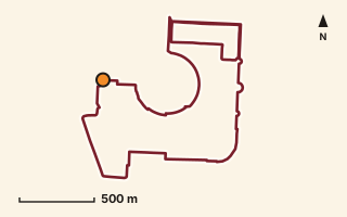
Route line on OpenStreetMap streets. Orange dot: start and finish. Road Running Magarpatta
Magarpatta City loop
West Gate Road, the township roads and footpaths to the Seasons Mall side, and round part of the Magarpatta Inner Circle.
One loop 6.2 kmUnderfoot 59% streets, 41% paths and tracks Elevation not recordedPlotted by PuneRunners on OpenStreetMap data Mapped only, not field-tested
Check before you go: Private township: confirm that runners from outside are allowed in, and when.
Safety and access: Magarpatta City is a private township. Check that runners from outside are allowed in before you go.
Streets: Magarpatta West Gate Road, Slip Road to Tower-3/4, Grevillea Road, Cosmos Road - Mahalaxmi Road, Oxygen Zone, Royastonea Society Road.
Route record
- Category
- RUNNING & TRAIL RUNNING
- Type
- Road Running
- Area
- Magarpatta
- City status
- PUNE CITY
- Distance
- 6.2 km
- Elevation gain
- Not recorded
- Difficulty
- Not recorded
- Technicality
- Not recorded
- Endurance
- Not recorded
- Navigation
- Not recorded
- Exposure
- Not recorded
- Remoteness
- Not recorded
- Terrain
- 59% streets, 41% paths and tracks (from OSM highway tags)
- Surface
- paving stones 31%, asphalt 29%, not tagged 22%, concrete 15%, dirt 3% (OSM surface tags)
- Monsoon risk
- Not recorded
- Heat risk
- Not recorded
- Wildlife
- Not recorded
- Water
- Not recorded
- Mobile network
- Not recorded
- Emergency access
- Not recorded
- Beginner suitability
- Not recorded
- Start
- Magarpatta West Gate Road (18.51515, 73.92214)
- Finish
- Magarpatta West Gate Road (18.51515, 73.92214), a loop
- Nearest landmark
- Magarpatta Inner Circle
- Creator
- PuneRunners, plotted on OpenStreetMap data
- Source
- OpenStreetMap streets and paths
- GPX
- Yes
- GPX link
- GPX file
- Licence
- ODbL 1.0 (derived from OpenStreetMap)
- Reuse
- Ours to publish; credit OpenStreetMap contributors, share-alike
- Route date
- 7 Oct 2026
- Last verified
- Not recorded
- Data confidence
- Plotted on mapped streets and paths; not field-tested
- Safety notes
- Magarpatta City is a private township. Check that runners from outside are allowed in before you go.
-
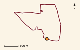
Route line on OpenStreetMap streets. Orange dot: start and finish. Road Running Kharadi
Kharadi loop
Kharadi South Main Road, Fountain Road, Downtown Road and Kharadi Road, east of the Kharadi bypass.
One loop 5.73 kmUnderfoot 100% streets Elevation not recordedPlotted by PuneRunners on OpenStreetMap data Mapped only, not field-tested
Safety and access: Public streets near the EON IT park. Weekday office traffic is likely; traffic and footpaths not checked.
Streets: Kharadi South Main Road, Fountain Road, Downtown Road, Lane Number A - 4, Kharadi Road, Rakshak Nagar Gold Road.
Route record
- Category
- RUNNING & TRAIL RUNNING
- Type
- Road Running
- Area
- Kharadi
- City status
- PUNE CITY
- Distance
- 5.73 km
- Elevation gain
- Not recorded
- Difficulty
- Not recorded
- Technicality
- Not recorded
- Endurance
- Not recorded
- Navigation
- Not recorded
- Exposure
- Not recorded
- Remoteness
- Not recorded
- Terrain
- 100% streets (from OSM highway tags)
- Surface
- not tagged 42%, concrete 32%, asphalt 25%, paving stones 1% (OSM surface tags)
- Monsoon risk
- Not recorded
- Heat risk
- Not recorded
- Wildlife
- Not recorded
- Water
- Not recorded
- Mobile network
- Not recorded
- Emergency access
- Not recorded
- Beginner suitability
- Not recorded
- Start
- Kharadi South Main Road (18.54918, 73.94294)
- Finish
- Kharadi South Main Road (18.54918, 73.94294), a loop
- Nearest landmark
- Not recorded
- Creator
- PuneRunners, plotted on OpenStreetMap data
- Source
- OpenStreetMap streets and paths
- GPX
- Yes
- GPX link
- GPX file
- Licence
- ODbL 1.0 (derived from OpenStreetMap)
- Reuse
- Ours to publish; credit OpenStreetMap contributors, share-alike
- Route date
- 7 Oct 2026
- Last verified
- Not recorded
- Data confidence
- Plotted on mapped streets and paths; not field-tested
- Safety notes
- Public streets near the EON IT park. Weekday office traffic is likely; traffic and footpaths not checked.
-
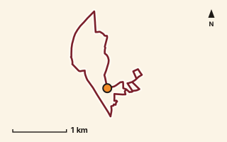
Route line on OpenStreetMap streets. Orange dot: start and finish. Road Running Savitribai Phule Pune University
SPPU campus loop
Campus roads inside Savitribai Phule Pune University: Main gate to IUCAA road, Joshi gate road, IUCAA back side road, the Main building road and the hostel roads.
One loop 7.03 kmUnderfoot 100% streets Elevation not recordedPlotted by PuneRunners on OpenStreetMap data Mapped only, not field-tested
Check before you go: University campus: confirm public access hours and any entry rules.
Safety and access: University campus. OpenStreetMap marks these roads as permissive, which means entry is allowed but can be withdrawn. Gate hours and rules not checked; ask campus security.
Streets: Main gate-IUCAA road, Girls' hostel road, Joshi gate road, IUCAA road, IUCAA back side road, SPPU Main building road.
Route record
- Category
- RUNNING & TRAIL RUNNING
- Type
- Road Running
- Area
- Savitribai Phule Pune University
- City status
- PUNE CITY
- Distance
- 7.03 km
- Elevation gain
- Not recorded
- Difficulty
- Not recorded
- Technicality
- Not recorded
- Endurance
- Not recorded
- Navigation
- Not recorded
- Exposure
- Not recorded
- Remoteness
- Not recorded
- Terrain
- 100% streets (from OSM highway tags)
- Surface
- not tagged 77%, asphalt 23% (OSM surface tags)
- Monsoon risk
- Not recorded
- Heat risk
- Not recorded
- Wildlife
- Not recorded
- Water
- Not recorded
- Mobile network
- Not recorded
- Emergency access
- Not recorded
- Beginner suitability
- Not recorded
- Start
- Main gate-IUCAA road (18.54789, 73.82809)
- Finish
- Main gate-IUCAA road (18.54789, 73.82809), a loop
- Nearest landmark
- Not recorded
- Creator
- PuneRunners, plotted on OpenStreetMap data
- Source
- OpenStreetMap streets and paths
- GPX
- Yes
- GPX link
- GPX file
- Licence
- ODbL 1.0 (derived from OpenStreetMap)
- Reuse
- Ours to publish; credit OpenStreetMap contributors, share-alike
- Route date
- 7 Oct 2026
- Last verified
- Not recorded
- Data confidence
- Plotted on mapped streets and paths; not field-tested
- Safety notes
- University campus. OpenStreetMap marks these roads as permissive, which means entry is allowed but can be withdrawn. Gate hours and rules not checked; ask campus security.
-
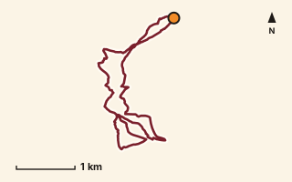
Route line on OpenStreetMap paths. Orange dot: start and finish. Trail Running Vetal Tekdi and ARAI
Vetal Tekdi and ARAI hill loop
Dirt paths over Vetal Tekdi and south to the ARAI hill, from the north-east edge of the hill.
One loop 9.47 kmUnderfoot 96% paths and tracks, 4% streets Elevation not recordedPlotted by PuneRunners on OpenStreetMap data Mapped only, not field-tested
Check before you go: Unlit hill paths: confirm path condition, safe hours and exits.
Safety and access: Unlit dirt paths on an open hill. Go in daylight and in company, and carry water. Path condition and access not checked.
Paths: ARAI Road.
Route record
- Category
- RUNNING & TRAIL RUNNING
- Type
- Trail Running
- Area
- Vetal Tekdi and ARAI
- City status
- PUNE CITY
- Distance
- 9.47 km
- Elevation gain
- Not recorded
- Difficulty
- Not recorded
- Technicality
- Not recorded
- Endurance
- Not recorded
- Navigation
- Not recorded
- Exposure
- Not recorded
- Remoteness
- Not recorded
- Terrain
- 96% paths and tracks, 4% streets (from OSM highway tags)
- Surface
- dirt 48%, not tagged 31%, earth 15%, ground 4%, gravel 3% (OSM surface tags)
- Monsoon risk
- Not recorded
- Heat risk
- Not recorded
- Wildlife
- Not recorded
- Water
- Not recorded
- Mobile network
- Not recorded
- Emergency access
- Not recorded
- Beginner suitability
- Not recorded
- Start
- Unnamed path (18.53913, 73.82673)
- Finish
- Unnamed path (18.53913, 73.82673), a loop
- Nearest landmark
- ARAI Road
- Creator
- PuneRunners, plotted on OpenStreetMap data
- Source
- OpenStreetMap streets and paths
- GPX
- Yes
- GPX link
- GPX file
- Licence
- ODbL 1.0 (derived from OpenStreetMap)
- Reuse
- Ours to publish; credit OpenStreetMap contributors, share-alike
- Route date
- 7 Oct 2026
- Last verified
- Not recorded
- Data confidence
- Plotted on mapped streets and paths; not field-tested
- Safety notes
- Unlit dirt paths on an open hill. Go in daylight and in company, and carry water. Path condition and access not checked.
-
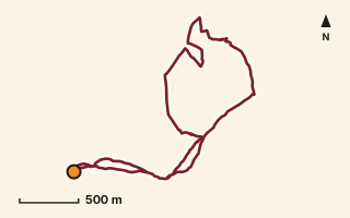
Route line on OpenStreetMap paths. Orange dot: start and finish. Trail Running Pashan and Baner hill
Pashan and Baner hill loop
Pashan Hill Trail and Baner Hill Trail over the Pashan and Baner hill, with short stretches of Pancard Club Road and Alpine Ridge Road.
One loop 6.11 kmUnderfoot 74% paths and tracks, 26% streets Elevation not recordedPlotted by PuneRunners on OpenStreetMap data Mapped only, not field-tested
Check before you go: Unlit hill paths: confirm path condition, safe hours and exits.
Safety and access: Unlit dirt paths on an open hill. Go in daylight and in company, and carry water. Path condition and access not checked.
Paths: Pashan Hill Trail, Baner Hill South Trail, Baner Hill Trail, Pancard Club Road, Alpine Ridge Road.
Route record
- Category
- RUNNING & TRAIL RUNNING
- Type
- Trail Running
- Area
- Pashan and Baner hill
- City status
- PUNE CITY
- Distance
- 6.11 km
- Elevation gain
- Not recorded
- Difficulty
- Not recorded
- Technicality
- Not recorded
- Endurance
- Not recorded
- Navigation
- Not recorded
- Exposure
- Not recorded
- Remoteness
- Not recorded
- Terrain
- 74% paths and tracks, 26% streets (from OSM highway tags)
- Surface
- not tagged 67%, dirt 33% (OSM surface tags)
- Monsoon risk
- Not recorded
- Heat risk
- Not recorded
- Wildlife
- Not recorded
- Water
- Not recorded
- Mobile network
- Not recorded
- Emergency access
- Not recorded
- Beginner suitability
- Not recorded
- Start
- Pashan Hill Trail (18.54855, 73.77623)
- Finish
- Pashan Hill Trail (18.54855, 73.77623), a loop
- Nearest landmark
- Not recorded
- Creator
- PuneRunners, plotted on OpenStreetMap data
- Source
- OpenStreetMap streets and paths
- GPX
- Yes
- GPX link
- GPX file
- Licence
- ODbL 1.0 (derived from OpenStreetMap)
- Reuse
- Ours to publish; credit OpenStreetMap contributors, share-alike
- Route date
- 7 Oct 2026
- Last verified
- Not recorded
- Data confidence
- Plotted on mapped streets and paths; not field-tested
- Safety notes
- Unlit dirt paths on an open hill. Go in daylight and in company, and carry water. Path condition and access not checked.
Distances are measured along the plotted line. Route lines and GPX files are derived from OpenStreetMap (opens in a new tab) data, © OpenStreetMap contributors, available under the ODbL 1.0. Ran one of these? Tell us in the WhatsApp group what the footpaths and traffic were like.